


If we think carefully about the flaws in measuring how dense a place is, we can better articulate what we actually value about urbanism.
One thing that many planners, economists, and urban reformers agree on these days is that density is a good thing. But there’s something deeply deceptive about density: Far from being a straightforward statistical measurement, it’s actually difficult to define and easy to manipulate. Thinking carefully about the flaws inherent in measuring density can encourage us to better articulate what it is about density that we actually value—and to emphasize those outcomes, rather than raw density itself, as objectives of foresighted urban design.
The problem with density as a statistical measurement arises from the fact that we have to make a choice about what geographic unit to use as the denominator in the formula of people divided by area which gives us density. That choice can lead to some strange flukes. If we measure the density of two people sleeping in a 40-square-foot tent in the wilderness of Alaska at the resolution of one tent unit, we get a density of 1.4 million people per square mile, or about 20 times the density of Manhattan. Meanwhile, the most recent census found 25 people living in New York City’s Central Park, giving the park a density of just under 19 people per square mile, slightly more rural than Idaho.
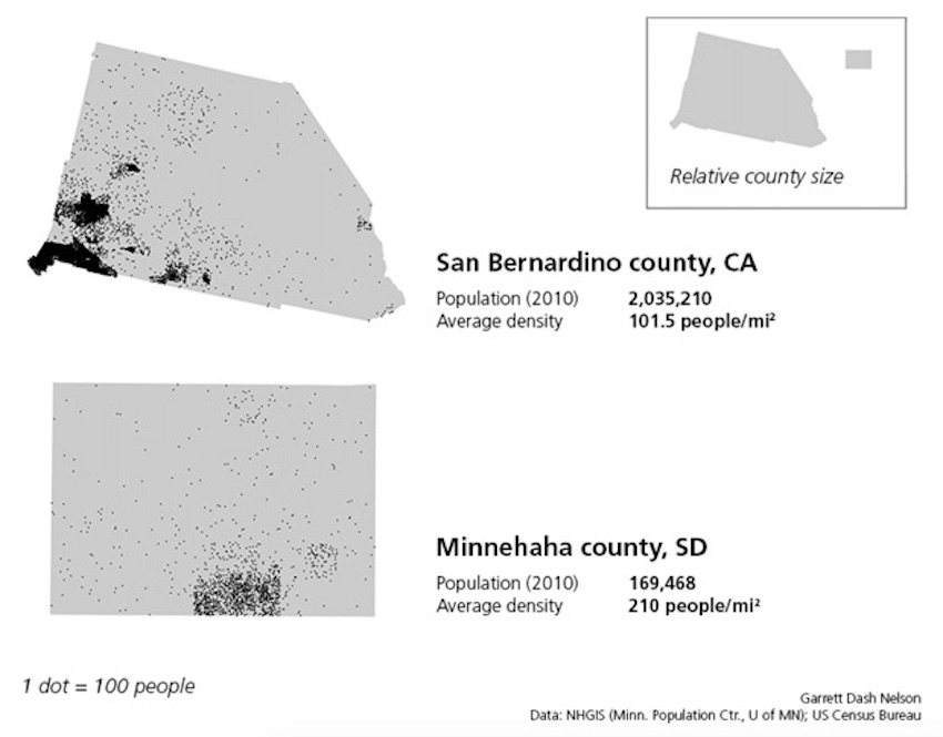
Geographers call this statistical quirk the modifiable unit area problem, and it can cause all sorts of trouble. For instance, counties are a commonly-used geographic unit for demographic analysis in the United States. But counties differ considerably in their shapes and sizes. San Bernardino County, California, is physically larger than the four smallest U.S. states combined, and it includes a large swath of the Mojave Desert. Consequently, San Bernardino’s average density—100 people per square mile—is less than half that of Minnehaha County, South Dakota. But the vast majority of people in San Bernardino County are clustered in the county’s southwestern corner, in what is essentially an extension of the Los Angeles megacity. By contrast, Minnehaha County, though it hosts Sioux City, the largest urban center in the nation’s fifth least-dense state, also contains 1,000 farms averaging 353 acres each. Is it correct to say that San Bernardino County’s residents go about their daily lives in a world that feels, on average, half as dense as the lives of an average Minnehahan? Probably not: The Census Bureau includes most of San Bernardino’s population inside Los Angeles’s “combined statistical area,” which is home to 18 million people, while the largest statistical area around Sioux Falls contains only 230,000.
From our partners:

There are some clever ways to get around the modifiable areal unit problem. For instance, measuring a cross-section of density at different distances from City Hall gives a better picture of how population masses radiate out from urban nodes. Geographers have some more sophisticated measurements which can identify how strongly the choice of unit areas is distorting a spatial statistic. But for discussions of urban density, the solution isn’t necessarily found in tweaking our math. Instead, we should be thinking about what it is about density we like: Rather than relying on measurements that simply take generic human dots and divide them by generic geographic areas, we should try to study the ways in which life is actually lived.
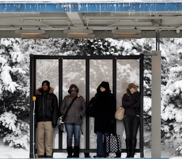
One reason to like density is that, at least in theory, it reduces commuting distance and time, which not only cuts down on carbon emissions but probably makes people happier, too. However, the relationship between density and commute times is far from a strict correlation. A dense city with all of its jobs in one congested central business district will likely experience much more painful commutes than a less-dense city where jobs and residences are evenly stirred together. Critics of the bloated metropolitan areas of the 1920s complained about the enormous time and effort spent carting people “from places they would rather not live to places they would rather not work and back again,” as described in a 1925 Survey Graphic article by the economist Stuart Chase. They realized that the length, difficulty, and expense of commuting patterns are the major factor in determining whether or not urban life is pleasant and convenient—not how jam-packed together everyone might be on average.
“Neighborliness is a virtue which grows from something more than tight quarters.”
Here, a better statistic than raw density would be a measurement which considers the average time and distance which is required for an individual to encompass a zone suitable for the purposes of everyday life. What we care about most in community planning is that people can get to the places they use regularly—their workplace, school, childcare, grocery store, café, and so on—in a convenient, affordable, and energy-efficient manner. Instead of averaging out raw densities across enormous areas, like the nearly 5,000 square miles that constitute the Los Angeles metropolitan statistical area, we should pay attention to the finer-grained geographies of human scale.
For instance, I recently moved to Lebanon, New Hampshire—population 13,000 at the last census—which, measured at the scale of its “micropolitan statistical area,” is very thinly spread. But because I live in the dead center of the city, I’m within a 500-foot radius of the post office, the library, a grocery store, a few restaurants, a park, the farmer’s market, and the bus stop that takes me to my office. In terms of a functional, lived experience, my everyday urban geography is considerably “denser” than many of my friends who live in Chicago or San Francisco.
But it isn’t just convenience and transportation efficiency that draws so many of today’s urbanists to prize density. They point to the ways that density nurtures both innovation and social diversity to argue that there are fundamental “agglomeration effects” which result from gathering people and businesses together in close proximity. There’s certainly something to this: the geographer Waldo Tobler’s famous “first law of geography” states that “near things are more related than distant things,” and we are undoubtedly more likely to participate in both acts of social solidarity and economic interchange with people who are close at hand than with those who are far distant.
![]() But it’s naïve to assume that all people have equal access to one another just because they happen to be bumping shoulders—a fantasy bred in the cozy atmosphere of elite college campuses and well-decorated coffeehouses. In reality, our social and economic interactions are highly stratified by barriers like race, gender, education, and class. An undocumented Latina immigrant might clean houses or bus tables in the same gentrifying neighborhood where an Ivy League-educated programmer has rented an expensive apartment, but that hardly means that the two will miraculously found a business or develop an art project together. In fact, as common goods like public transit systems give way to individualized services like Uber, it becomes even easier to construct parallel, insulated worlds that share spatial proximity but little else. Neighborliness is a virtue which grows from something more than tight quarters: It requires institutions, policies, and resources that actively work to promote equality, interaction, and meaningful mutual participation.
But it’s naïve to assume that all people have equal access to one another just because they happen to be bumping shoulders—a fantasy bred in the cozy atmosphere of elite college campuses and well-decorated coffeehouses. In reality, our social and economic interactions are highly stratified by barriers like race, gender, education, and class. An undocumented Latina immigrant might clean houses or bus tables in the same gentrifying neighborhood where an Ivy League-educated programmer has rented an expensive apartment, but that hardly means that the two will miraculously found a business or develop an art project together. In fact, as common goods like public transit systems give way to individualized services like Uber, it becomes even easier to construct parallel, insulated worlds that share spatial proximity but little else. Neighborliness is a virtue which grows from something more than tight quarters: It requires institutions, policies, and resources that actively work to promote equality, interaction, and meaningful mutual participation.
In the 1960s, the Swedish geographer-planner Torsten Hägerstrand pioneered a technique called the “space-time cube” in order to visualize how people move around cities throughout the day and come into temporary conjunctures with others in places like transit stops, workplaces, or leisure facilities. By diagramming the paths that people weave through the city, it becomes possible to distinguish between a vibrant form of density, which features many sites of fair, equitable human interaction, and a mere heaped-up density, which features people jostling against one another without ever producing meaningful social relationships. We can do so by paying close attention to the moments and places where spatial proximity promotes the growth of democratic ties cutting across lines of suspicion and division—for instance, in a public soccer field shared by many different kinds of people.
More intensive studies of the spatial structure of cities, like ones that scrutinize the distance and stress of individual commutes or observe how people interact with one another in public spaces, are hardly easy. They require not only dedicated researchers, but, more importantly, a careful sensitivity to the social life of urban landscapes. That’s why we often rely lazily on an easy-to-compute statistic like density as a convenient shorthand for what’s praiseworthy about urban life. But we should try harder to look beyond density to explain—and advocate for—what it really is about proximity and neighborliness that we really admire.
This feature originally appeared in Citylab.

From our partners: