


A popular new study claims to lump cities into four types. But the real science of cities is heading toward a more complex understanding of how urban spaces evolve.

Before Darwin, science tried to make sense of the natural world through a slew of systems of classification. Linnaeus’ taxonomy, for example, grouped living things together based on their appearance, or “morphology,” in kingdoms, classes, orders, genera, and species.
“All taxa show relationships on all sides like the countries on a map of the world,” Linnaeus wrote, grasping threads of evolutionary theory—which is to say, that everything on earth descends from a common relative, and that the divergence of life, driven by natural selection, can be traced through physical traits (and later, genetics).
In the “science of cities,” we may be approaching a moment where mere classification — a long tradition in the urban-planning world — and untested hypotheses are moving toward a unified model.
But evolutionary theory had to come after Linnaeus, and not to mention, after wobbly ideas of species’ “transmutation” and orthogenesis were debated and discarded. Eventually Darwinism eclipsed competing notions of evolution, and in essence remains the foundation of all natural sciences.
From our partners:
In the so-called “science of cities,” we may be approaching a moment where mere classification of city types—a long tradition in urban studies—and vague, untested hypotheses are moving toward a more unshakable model or how cities evolve.
Take, for example, a headline from a couple of weeks ago. Gizmodo, Popular Mechanics, Atlas Obscura, Motherboard, and Discovery announced that there are only four kinds of cities in the world—apparently, a new mode of classification for cities.
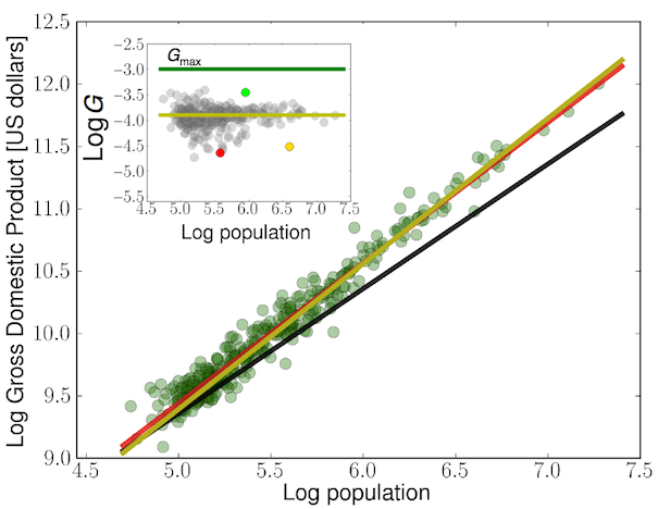
The study described in these articles goes something like this: Using data mostly from OpenStreetMap, French theoretical physicists Marc Barthelemy and Rémi Louf measured the size and shape of land blocks in 131 global cities, meaning the sections of land chunked out by the surrounding street network:
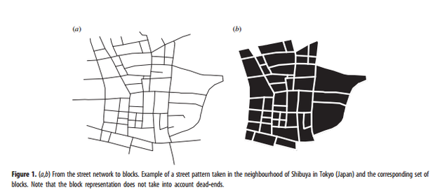
Then they charted the occurrence of those shapes and sizes within all of those cities. Some cities had lots of uniformly shaped blocks. Others had more tiny, curvy blocks. They compared the different distributions of blocks, and lumped them together into four different “groups”:
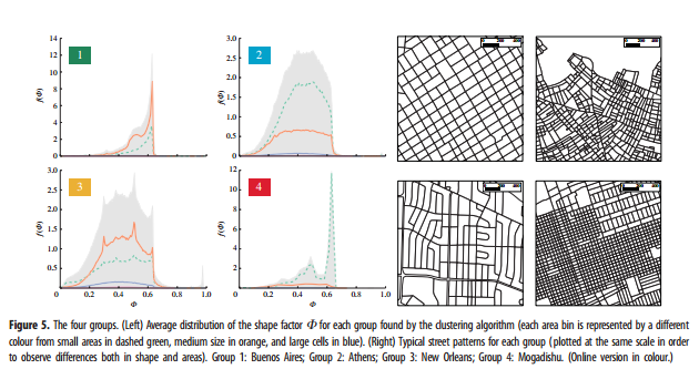
With the exceptions of Buenos Aires and Mogadishu—whose block patterns were so unlike any other in the world that they each stood alone—the cities all fell within two groups: Group Two, which contained most in the Middle East, Asia, and South America; or Group Three, which contained most North American and European centers. There were some outliers: Vancouver “intruded” into Group Two, and in Group Three’s subgroups, Boston fell in with Paris and Venice.
The study claims it is “the first quantitative proof that Boston feels like a European city.” But its authors also argue it is among the only strictly quantitative methods of categorizing cities, period.
“Generally speaking, there are no solid scientific foundations in urban planning and even in urban economics,” writes Barthelemy in an email. “[But] the recent availability of data [allows] us to test ideas, models, etc, and to construct the hierarchy of mechanisms—i.e., to determine the order of magnitude of importance of the various mechanisms that are at play in the evolution of a city.”
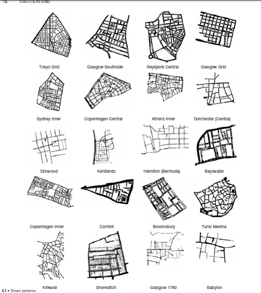
But does “four kinds of cities in the world” actually illuminate a “hierarchy of mechanisms”? Or is it just another method of classification—which geographers and urban theorists have been coming up since the early 20th century? “There are dozens of classification systems out there, some are lyrical, some metaphorical, other more mathematical,” says Stephen Marshall, an urban planning researcher at UCL and author of Streets and Patterns, which catalogs a number of street pattern-based classification systems. “Each classification tells a story about what’s it’s trying to say.”
It would be impossible to attempt to list all the ways of categorizing cities here, but to give you an idea: Plenty are based on the city’s function and size, like Chauncy D. Harris’s 1943 “Functional Classification of Cities in the United States”:

More modern approaches to cataloging cities by function can be found in books like Paul Knox’s recent Atlas of Cities, which describes 13 different city “types”: “Foundational” cities; “Imperial” cities; “Industrial” cities, “Megacities”; and “Green” cities, to name a few of the “kinds of cities produced by the patterns and processes of urbanisation, past and present.”
These kinds of classifications, says Knox, are best understood as a primer to the basic issues of urbanization. “It’s horses for courses,” he says. “Something like the Atlas would hopefully help planners because it will increase the number of people who understand what kinds of function cities fulfil and the different kinds of problems they face.”
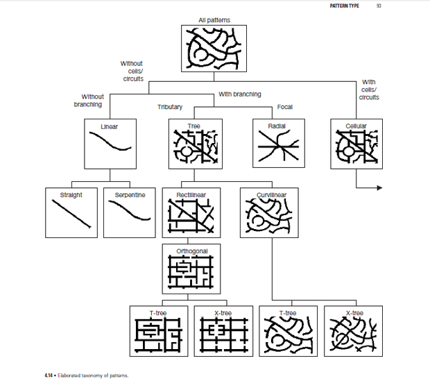
Other modes of classification center on the morphology of the city’s street patterns, which Marshall details in Streets and Patterns:
There are other, more abstract modes of classification. In the 1965 urban studies classic A City Is Not A Tree, Christopher Alexander distinguishes between natural from artificial cities—cities that have “arisen more or less spontaneously over many, many years” versus cities “deliberately created by designers and planners.”

He argues that the difference in their basic structure (a “semilattice” of overlapping parts—from modes of transport to “pub-crawling,coffee-drinking, the movies,”—versus the eponymous “tree” that separates out these units of city life) helps explain why “artificial” cities can never duplicate the spontaneous, creativity-inducing, playful qualities of “natural” cities. Taken further, Alexander’s theories could be said to go as far as arguing that planning a city is basically useless.
Other classic tomes of urban design—from Jane Jacobs’ The Death and Life of Great American Cities,to Kevin Lynch’s Image of A City, might do less to explicitly categorize cities based on their appearance, but they do make theories about what a “good” city should be—based on appearance. As Marshall blocks out in a 2012 Urban Design article, Jacobs even goes so far to prescribe the necessary “ingredients” of a “great” city:
To generate exuberant diversity in a city’s streets and districts, four conditions are indispensable:
The district … must serve more than one primary function ….
Most blocks must be short ….
The district must mingle buildings that vary in age and condition ….
There must be a sufficiently dense concentration of people ….
Yet these approaches to classification, or descriptions of the characteristics of a city, largely examine cities as entities—as objects that take up space, that have a function that look a certain way. They classify based on appearance or morphology, much like Linnaeus and others did in the days before genetics.
But many argue that some of the most basic theories of classification and characterisation of a “good” city have little basis in science or testing. Michael Mehaffy wrote here last month, “Jacobs was famous for excoriating the backward-looking “pseudo-science” of that era’s planning and architecture, which she said seemed “almost neurotic in its determination to imitate empiric failure and ignore empiric success.” Yet Jacobs herself wasn’t exactly rigorously scientific. Her “recipe” for great cities wasn’t ever scientifically tested or borne out by scientific evidence.
“We need more rigor” if urban designers and planners want to chart and guide this extraordinary time of rapid growth.
That calls for some serious self-reflection on the part of urban thinkers, argues Marshall. “We need more rigor,” he says, especially as more than half the world’s population now lives in cities, and by some estimates, as nearly one million more people are added to urban centers every week. Marshall and many others are making the case that defining and comparing cities by their morphology is no longer sufficient if urban designers and planners want to chart and guide this extraordinary time of rapid growth.
“Urban studies illustrates the diversity of cities, the conditions under which cities are built,” William Solecki, director of the C.U.N.Y. Institute for Sustainable Cities, told Eric Jaffe last year. “But that really, in large part, hasn’t focused on the process through which there’s this ongoing development or change of cities. … one of the things we can start to ask is how do we look at cities as not only objects, but also to look at them in a slightly more sophisticated way.”
And so the old modes of classification are giving way, slowly, to a field in search of a unified theory of evolution, or towards a stronger, more scientific… science of cities.
In a 2013 article in Environment, Solecki and his colleagues outlined their basic research goals for a proposed re-envisioning of the field:
- To define the basic components of urbanization across time, space, and place.
- To identify the universal laws of city-building, presenting urbanization as a natural system.
- To link this new system of urbanization with other fundamental processes that occur in the world.
This is possible, argues Solecki, with the avalanche of data that’s now available on how cities work—from where crime happens, to how many riders ride transit, to blocks of blight, to the intersections where cars hit the most pedestrians, to open street maps (which, it bears repeating, Barthelemy and Louf made use of in their work). Now it’s time to create a consistent, solid, framework for analysis of that data.
“The problem is not so much about finding out about some aspect of urbanization but how we can effectively put the data together,” says Knox, author of Atlas of Cities. “And what this will do is shift us away from subjective or qualitative approaches—which are mostly versions of correlation—to what they’re doing in natural sciences, which is really co-evolution. How do voting patterns change as the geography of the city changes? How do crime patterns change? It’s a dialectic process.”
And it is probably more dynamic than fingerprinting street patterns and saying that Boston is a quantifiably “European.” “What we’re really looking at are the forces, the laws, the principles, the axiomatic statements that we can say about how these cities are constructed, built, and rebuilt,” Solecki said. “So the object of study isn’t so much [the city itself]. It’s the process of building that thing.”
“What I like to think about in cities is, Why do they exist?” says Luis Bettencourt. “What allows us to do the things together as a society of strangers that we can’t alone? It’s all magnified in myriad ways—with cultural consequences, material consequences, in how we manage and obtain resources. I want to understand how all the heck this happens.”
Bettencourt, a physicist by training, is one half the Santa Fe Institute’s far-out duo studying cities, scaling, and sustainability. He and Geoffrey West have long been looking at how urban morphology—the shapes of cities—is connected to the economic and social patterns inside.
Using that avalanche of data hitherto described, they and their colleagues have systematically worked to establish the quantifiable characteristics of cities as a whole: The length of road networks, the average income of inhabitants, the number of patents per capita. As Emily Badger explained here last year, Bettencourt and West have compared the relationships between these characteristics and the population growth of a city, examining how infrastructure grows, how socioeconomic output is linked to increased social interaction, and how density develops to minimise the energy costs of that interaction.

According to their findings, across the globe and throughout history, these characteristics grow predictably along with city population; in other words, cities “scale” in astonishingly predictable ways. The next step for Bettencourt and West is to develop a mathematical description that successfully predicts what creates these scaling patterns.
“What I like to think about in cities is, Why do they exist?”
And that is where Barthelemy and Louf—they of the city block classifications— eventually see their research going, even as plainly morphological as their first findings are. Eventually, says Barthelemy, “we want to disentangle all thedifferent factors that shape a city, and try to understand what the main mechanism.”
So are we getting closer to an evolutionary theory of cities? Can there be a grand, unified law of how cities grow, scale, and shape-shift to hang all of urban studies upon? Perhaps—though some of the strongest proponents of the “quantifiable city” aren’t sure.
“Maybe there’s some unequivocal explanation out there,” says Michael Batty, author of The New Science of Cities, which lays out mathematical models designed to predict human interactions and resource flows in cities. “But I tend to think that’s almost impossible, given how cities are made of individuals. Maybe we’d have some measurements that will be stable for a time, but they’d be bound to change eventually.”
Maybe. Or maybe the science of cities is still in its pre-Darwin days: a juvenile field, with systems of classification and shaky theories of evolution growing towards something great.
This article originally appeared on CityLab.


From our partners: