


Two Yale architects pose the question in an ambitious research project.
It’s difficult to think about global urbanisation at the scale of individual cities. There’s no such thing as the model metropolis that mirrors the development patterns and sustainability problems of urban areas everywhere. Isolating any one city is impractical anyway; they now increasingly spread into and impact one another, blurring the boundaries between urban and rural, between developed and natural land, between metros, megalopolises and mega-regions. And then there is the simple problem of definitions: “What’s considered ‘dense’ in Australia,” says Yale School of Architecture critic Joyce Hsiang, “is rural in China.”

How then do we begin to think about the consequences of worldwide urbanisation, what Hsiang calls “the greatest design challenge we’re faced with”?
“It’s impossible to look at the city as a kind of discrete entity any more given the way financial networks, ecological networks, social networks work,” says Bimal Mendis, an assistant dean at Yale*, who is working with Hsiang, a critic at Yale and principal at Plan B Architecture & Urbanism. “These systems have much larger footprints than the actual physical or political boundaries of cities.”
From our partners:

Hsiang and Mendis have increasingly come to believe that the only way to study and plan for our urban planet is to conceptualise its entire population in one seamless landscape – to picture 7 billion of us as if we all lived in a single, massive city.
[infobox]For too long, the architecture profession has been complicit in focusing on buildings and the scale of buildings.[/infobox]This is the premise behind an ambitious research project, called “The City of 7 Billion,” for which the two recently won the $100,000 Latrobe Prize from the American Institute of Architects College of Fellows. With the geo-spatial model Mendis and Hsiang are creating – think a super-enhanced, zoomable Google Earth, Hsiang says – they’re hoping to study the impact of population growth and resource consumption at the scale of the whole world.
Every corner of the planet, they argue, is “urban” in some sense, touched by farming that feeds cities, pollution that comes out of them, industrialization that has made urban centers what they are today. So why not think of the world as a single urban entity?
Hsiang and Mendis don’t yet know exactly what this will look like (that is the question, Mendis says). But they are planning to seed their geo-spatial model with worldwide data on population growth, economic and social indicators, topography, ecology and more. Ultimately, they hope, other researchers will be able to use the open-source platform for research on development patterns or air quality; the public will be able to use it to grasp the implications of building in a flood plain or implementing an energy policy; and architects will be able to use it to view the world as if it were a single project site.
The whole endeavor grows out of a pair of earlier research projects. One looked at existing metrics of “sustainability” in an attempt to define and measure that abstract concept in cities.
“There’s LEED codes, land codes – everybody has their own thing. And you go into it thinking ‘We’re going to come up with another one tailored to this type of project!’” Hsiang says. But she and Mendis ultimately decided that they could more usefully figure out how to integrate existing, interconnected metrics into a spatial model.

And they have now already done this with one measurement of urbanization: the world’s population distribution relative to land use. Conveying this information at the global scale required multiple datasets (from the Census Bureau, from the United Nations, from development banks, etc.). Hsiang and Mendis had to sort out the inconsistencies in that data, resolve the multiple ways different countries and organizations produce it, and stitch it all together.
This animation captures how they then visually illustrated this population density data in a 25-year time sequence, from 1990 to 2015, across dozens of cities. Each little white column represents the population living on a parcel of land 25-by-25 kilometers in size:
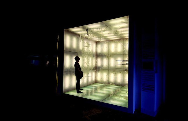
Hsiang and Mendis then turned that spatial visualisation into a physical installation at the 2011 Chengdu Biennale in China. They modelled the population distribution of the entire world in a kind of inverted map that visitors could walk into, inside a 10-by-10-by-10 foot room, with North America on the ceiling, Asia on one wall, Africa on another (see also the little boy in the above photo):
That installation made tangible what academics sometimes describe as the “spikiness” of global development. “People know these things abstractly,” Hsiang says. “But it’s entirely different when you actually can see it.”
Now she and Mendis will be trying to do something similar – sew together disparate data sets, turn them into spatial models, then make those models accessible to the public – with a vastly more complex scenario. They want to connect not just land use with population density, but also income data, carbon dioxide levels, and geographical terrain. Their model of the whole world as one continuous urban terrain could then be used as a predictive tool for planning development into the future.
[infobox]”A lot of what we do as architects is we help people see something that’s not physical.”[/infobox]Hsiang and Mendis are hoping to communicate data and ideas that the political and scientific communities have had a hard time conveying to the public. This may sound like an odd job for architects – visualizing worldwide data about air quality – but Hsiang and Mendis argue that architects are precisely the professionals to do this.
“This is what the architect has done for centuries,” Hsiang says. “A lot of what we do as architects is we help people see something that’s not physical.” This may mean visually rendering the dreams you have for the ideal kitchen, or a new neighborhood library, or an entire city plan. Politicians communicate through words and policies, Hsiang says, and scientists do the same through research. But architects – early interdisciplinary experts – can translate all of all of the above into spatial terms that the rest of us can understand.
More often, however, they have not been working at the same scale as policy-makers and scientists. “For too long, the architecture profession has been complicit in focusing on buildings and the scale of buildings,” Mendis says. “And I think that’s been detrimental to us.” The City of 7 Billion is an attempt to change that, to involve architects in big-picture questions more often debated by economists and geographers and social scientists.
By the end of their two-year research award, Hsiang and Mendis will have produced a publicly accessible web-based geospatial model with some core metrics baked in. By that point, the “city” will be usable by other researchers, planners and architects as well. Picture, for instance, planners in Dhaka, Bangladesh using it to project where local population pressure will come from 10 years from now. “That information is correlated with rising sea levels,” Mendis says. Perhaps those planners will discover, he says, “that whole region will be under water.” Now the challenge becomes one of regulating development to avoid the convergence of these two stories.
He and Hsiang expect the City of 7 Billion to be an indefinite work in progress, beyond the next two years. “This is a kind of project that when you embark on it,” Hsiang says, “you kind of embark on it for the rest of your life.”
This article originally appeared in CityLab.


From our partners:


